🏡 New Jersey's #1 Property Database
Search Any NJ Property
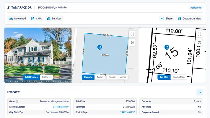
Instant access to property records, maps, and reports — all in one place on an easy to use platform.
3.2M
properties
50k+
members
25k+
daily searches
Daily
updates
See how our platform provides fast, reliable property data.
Trusted by 50,000+ real estate professionals in New Jersey


Why Us
Why NJPR
We are the premier property resource database in New Jersey, trusted by thousands of clients to enhance and optimize their workflow.
Property Data
Experience the most complete property data collection in NJ from 1989 to present. Data is updated daily and we aim to have the latest information.
Property Documents
Browse our statewide collection of: Tax Maps, Zoning Maps, Property Record Cards (PRCs), Deed Images, and Mortgage Images.
Map Features
View ownership & property data upon click of the parcel. Overlay various basemaps, analyze trends, delineate boundaries, and explore much more.
Reports & Labels
Quickly generate detailed reports, perform advanced property searches, and create mailing labels—all in one easy-to-use platform.
Features
Real Estate Solutions
Unlock actionable property insights and tools to power your real estate decisions.
Tax Assessment Data
Access comprehensive tax assessment records including property values, assessment history, exemptions, and detailed tax information for any New Jersey property.
Read more
Georeferenced Maps
We've created a feature that overlays tax or zoning maps on aerial views, providing a unique property perspective. Say goodbye to the hassle of locating the subject property on a document.
Read more
Property Record Cards
Complete building and property record cards containing detailed information about structure characteristics, room counts, features, and assessment methodologies.
Read more
Deed Images
Access high-quality scanned images of original deeds, providing complete legal documentation and property transfer history with searchable metadata.
Read more
Mortgage Data
Comprehensive mortgage information including lender details, loan amounts, mortgage history, and lien information for complete property financing insights.
Read more
Foreclosure Data
Track foreclosure proceedings, notices, auction dates, and foreclosure history to identify distressed properties and investment opportunities.
Read more
Street Map
Interactive street maps with property boundaries, address verification, neighborhood context, and detailed geographic information for precise property location.
Read more
Construction Permits
Access building permits, construction history, permit values, and project details to understand property improvements and development history.
Read more
Property Hazards
Identify environmental risks including flood zones, wetlands, contaminated sites, and other hazards that may affect property value and safety.
Read more
Mailing Labels
Generate professional mailing labels and contact lists for property owners, enabling targeted marketing campaigns and direct mail outreach.
Read more
Flood Determinations
A certified flood determination report assesses whether a property is in a flood hazard area, informing the requirement for flood insurance and compliance with federal regulations.
Read more
Generate Detailed Reports
Generate detailed property reports that include: A Cover Page, Basic Report, Tax & Assessment History, Deed History, Flood & Wetlands, Tax Map Sheet, Zoning Map Sheet, and the Deed Image.
Read more
Historical Data
Access comprehensive historical property records including past sales, ownership changes, assessment trends, and property evolution over time.
Read more
Export Data
Export property data in multiple formats including Excel, CSV, and PDF. Customize your exports with specific fields and filtering options for your workflow.
Read more
Custom Data & APIs
Looking for a custom dataset, API, or specialized component integration? Our experienced team is ready to customize any data from our website to meet your specific needs.
Read more
Member Benefits
Through our partnership with NJReap.com, subscribers enjoy exclusive member benefits including discounted title searches, priority processing, and access to premium property research tools.
Read more
Pricing
Membership Plan
Choose the plan that fits your needs and start exploring NJPropertyRecords today! Enjoy transparent pricing, flexible plans, and reliable data.
Property Data Platform
Search Smarter
Get fast, reliable property data from trusted sources. Use advanced filters to find properties quickly. Enjoy quick support via live chat, Monday through Friday.
Current Data
Our team is committed to continuously acquiring and processing a diverse range of property data. This information is meticulously gathered from trusted sources, including state and county courthouses, as well as public records.
Advanced Filters
Filter through statewide property records with the ability to apply various filters to locate your desired properties. Filters Include: Absentee Ownership, Property Class, Year Built, Acreage, Sales Price, Deed Date, and much more.
Fast Support
We provide live chat support on our website Monday to Friday, 8 AM to 4 PM EST, where our dedicated support agents are available to assist you promptly and happily welcome your valuable feedback, thoughtful questions, or insightful suggestions.
Get Started Today
Ready to Transform Your Property Research?
Join thousands of professionals who trust our platform for all essential property data in one place.
Join 50,000+ Users
Trusted by professionals statewide
Reliable Data
Updated daily from trusted sources
Comprehensive Data
All essential property data in one place
© 2026 NJPropertyRecords, LLC. All rights reserved.